FRESNO, Calif. (KFSN) — Rain and snow are in the forecast for Central California this week.
Much of the Valley can expect to see rainfall beginning Monday night into Tuesday afternoon.
The Valley can expect heavy showers and thunder at times, with some concern for flooding and slick roadways.
A Flood Watch will take effect for Foothill communities Monday evening with up to two inches of rain possible.
Flooding in recent burn scar areas is also possible.
A Winter Storm Warning will impact all areas of the High Sierra above 6,000 feet.
Up to one to two feet of snow is projected for the areas.
Drivers should take extra precautions if travel is necessary to the mountains. It could also be impossible to travel due to the conditions.
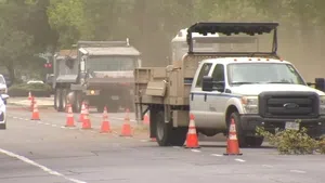
With the weather ahead, preparations are underway.
Fresno County Supervisor Nathan Magsig says crews will be working around the clock to make sure roads are open and secure.
”Right now, our public works department is monitoring areas that have been affected by the Garnet Fire. Most recently, we may have some limited mudslides, but also there’s a lot of trees that can potentially fall,” he says.
If you see downed trees during the storm, you can report them on the FresGo App.
If it’s creating an immediate safety hazard, call 911.
Expect high temperatures for the day to remain in the 60s until Thursday, where a return to the 70s is expected with sunny conditions and reaching nearly 80 degrees in the weekend.
For sandbags in Fresno County click here: https://www.fresnocountyca.gov/Departments/Public-Works-and-Planning/divisions-of-public-works-and-planning/road-maintenance-and-operations-division/sandbags-for-flood-prevention?fbclid=IwZXh0bgNhZW0CMTEAAR7PqCz3iPlcND9ttEtMa9kc7xabj5PJVZLOJOhDJqIrJWoXlw0uYbjfs0albA_aem_g8m8G_XeqgnO_MUfWUnkoA